 Print
page Print
page Email
to friend Email
to friend

TODAY'S WEATHER
Sunny
70°F (21.1°C)
Latitude:
00 deg 35'S
Longitude: 91 deg 44’W
Wind Direction: S
Wind Speed: 22 Knots
Sea State 3
Swell(s) Height: 3-6 Foot
Sea Temperature: 61°F (16.3°C)
Barometric Pressure: 1012.6 MB
Visibility: 12 Nautical Miles

Breakfast
Fresh fruits
Yogurt
Bacon and cheese muffins
Eggs and potatoes
Bacon, ham and sausage
Pancakes
Oatmeal
(Dried cereal is always available in the pantry)
OJ in a bucket
Lunch
Fresh salad
Pasta Turkey pot pie
Cream of mushroom soup
Dinner
Fresh salad
BBQ ribs
Catfish
Roast potatoes
Rice and vegetables
Fresh bread
German chocolate cake

A New Toy for King Neptune - Farewell to the Towed Camera
September 10, 2001
by Christina Reed
“Stop
the ship!” Dan yelled into the intercom to the bridge.
Two minutes later what started as a day filled with expectation,
ended in hard work and disappointment.
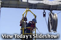
After a smooth and successful deployment of the WHOI digital towed
camera yesterday morning, we began taking pictures of the seafloor
on the northwest rift zone of Fernandina at a depth of 1700
meters. The tow was intended to give us a look at what we thought
would be the freshest, and some of the youngest, submarine
lava flows in the area. It would also provide data Jenny Engels
could use to compare this area with the first tow images we
saw on Sept. 6 from the young-looking flows in deeper water,
far away from the rift.
At 10:46 a.m. the ship was merrily pulling
along the camera at 1/3 knot and about 8 meters off the bottom
- an ideal height to take deep-sea pictures. Then: Whamo! The
tension on the tow wire started increasing. We paid out the wire,
but the tension continued to increase - fast. Dan called the
bridge. In the seconds it takes for the ship to stop, the steel
trawl wire broke.
The towed camera is blind to features directly
ahead of it and sometimes the subtle contours of the seafloor
become difficult hurdles. We think the camera caught a tall,
steep-sided lava formation that we were unable to see either
on the pinger trace, which tells us how far the camera is above
the seafloor, or on our sonar maps. The multibeam sonar maps
cannot image tall, thin chimney-like features. The maps can only
tell if features are taller than 10 meters if they are wider
than a football field.
The rest of the morning and into the late afternoon,
the Revelle’s Engineering
Department, the Resident Tech., and the Seamen all helped to haul the 500 meters
of wire that was hanging below the ship safely back on board. After much discussion
it was decided that it would be much too risky to try to grapple for the sled.
This would be like dangling a fishing line and hook off a 1700-meter-high building
and trying to catch a gold ring.
“It's always tough when something like this happens,” Dan said. “But
the ship’s crew was terrific - they gave it 200% effort.” When you
do work near the bottom of the ocean, there are always lots of risks to equipment.
Marine scientists try to avoid most of them with available technology, but sometimes,
King Neptune gets his way.
[Back to top]
|
