Print
page Print
page Email
to friend Email
to friend

TODAY'S WEATHER
Partly Cloudy
70°F (21.1°C)
Latitude:
00 deg 21.1'S
Longitude: 91 deg 55’W
Wind Direction: SSW
Wind Speed: 14 Knots
Sea State 3
Swell(s) Height: 2-4 Foot
Sea Temperature: 67°F (19.4°C)
Barometric Pressure: 1015.5 MB
Visibility: 15 Nautical Miles

Breakfast
Fresh fruits
Yogurt
Muffins
Huevos Rancheros
Potatoes
Bacon, ham and sausage
Pancakes
Oatmeal
(Dried cereal is always available in the pantry)
OJ in a bucket
Lunch
Fresh salad
Cheeseburgers
Navy bean soup
French fries and onion rings
Candy bars
Dinner
Fresh salad
Szechwan beef
Broccoli
Fried rice
Egg rolls
Fresh bread
Apple pie and ice cream


Lights, Camera, Seafloor Action!
September 6, 2001
by Christina Reed
Most scientists want to use Alvin or an ROV such as Jason for
their research -- they want to see the terrain first hand. “But
in a lot of cases,” Dan Fornari says, “all we need
are a few photographs to confirm or disprove our hypothesis
about a piece of seafloor.”
In 1994, deep-sea cameras generally relied
on 35-millimeter film, which had to be developed on board the
ship. “That was a real pain,” Dan says. Working
with engineers at Benthos Inc., in Falmouth, MA, Dan helped devise an easy to
use deep-sea camera for seafloor imaging.
With the capability to store 2200 images on a hard drive and take
pictures for about 8 hours at the bottom of the ocean, the
WHOI deep-sea digital camera is simple, yet it’s the only
one of it’s kind.
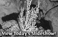
Last night, tethered to the Revelle by 3,000-meter
of trawl wire, the WHOI deep-sea digital camera hovered less
than 10 meters over the seafloor, flashing powerful strobe lights
and snapping a photograph every 15 seconds. We drove the camera
over the changing terrain without touching, most of the time.
A wire cage surrounds the camera, protecting
it from smashing into the rocks we can’t see. A pinger attached on the camera allows us to know how far
above the seafloor the camera is. But we have to be prepared to respond quickly
to any changes on the bottom, because the pinger only looks straight down.
“We have an idea of the changes as we move very slowly, and can use our
side-scan sonar map to give us an idea of what to expect,” Jenny Engels
says. “The digital images allow us to see the seafloor lava flows at a much
higher resolution.”
Each picture is four meters by six meters across.
Seeing the seafloor this close, we can identify pillow lava,
lobate flows, sheet flows, the collapse of a lava flow and fissures
in the seafloor. Curious fish swim under the camera lens, while
crabs, starfish and anemones are pictured along the way. Last
night, the deep seafloor around the Galápagos Islands was photographed for the first time.
[Back to top]
|