|
|
  TODAY'S WEATHER Cloudy with scattered showers 80.6°F (27°C) Latitude: 3 deg 29’N Longitude: 102 deg 15’W Wind Direction: S Wind Speed: 9 Knots Sea State 1 Swell(s) Height: 4-6 Foot Sea Temperature: 82.4°F (28°C) Barometric Pressure: 1012 MB Visibility: 10-25 Nautical Miles  Breakfast Mushroom and onion omelet Glazed doughnuts and waffles Bacon and Sausage Hash browns and hot cereal Eggs to order Assorted tropical fruits Assorted dry cereals Lunch Club Sandwich Crab salad Potato salad Vegetable beef soup Salad bar Brownies Dinner Chicken Cordon Bleu Fettucini Alfredo Bread stuffing Steamed asparagus Fresh wheat dinner rolls Salad bar Boston cream pie 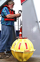
Tom Crook April 1, 2000 By Dr. Dan Fornari and Julia Getsiv RV Melville arrived on station at the 3° 20’N survey area at 0141 hours local time. How close did you come to estimating our arrival time from the distance and speed information I posted in yesterday’s Daily Journal? As soon as we got to the site, we started a 7 hour multibeam survey over the area where we will be working for the next week. (For more information on multibeam mapping, see the "Sonar" section under “Oceanographic Tools” in “About the Cruise”.) RV Melville continued at a speed of about 12 knots during the survey and we covered an area of approximately 350 nautical miles (nearly 1200 square kilometers). That is an area about 5 times the size of Manhattan Island in New York City! Uta Peckman, the Scripps multibeam data processor, was busy all day processing the data and she has produced beautiful maps of water depth with an accuracy of about 10 m that help us understand the morphology (shape) and topography of the East Pacific Rise. The maps will also help us to fly the DSL-120 sonar over the bumpy seafloor. This morning, the air was thick with humidity as the Deep Submergence Operations Group assembled on the fantail to deploy three “transponders” to help us navigate the DSL-120 sonar and Argo II mapping systems that we will use in the coming week. As the first transponder was deployed, a warm gentle rain began to fall and everyone enjoyed how refreshing it was after sweating in the damp heat. Shortly after that, it began to pour and the group had to take cover. As we approached the first drop site, the transponder was lowered into the water. As the ship moved slowly away, Tom Crook, Randy Dickau and Rob Palomares began to pay out the tether line. After all 200 meters of tether line were paid out, they kicked the anchor over the side, and it sank to the seafloor taking the transponder with it. The transponders look like big
yellow hard hats. They contain equipment that can listen for and also send
sound signals. The ship and the mapping vehicles “talk” and “listen” to
the transponders to navigate. The transponders “speak” using
sounds of different frequencies so that the ship or towed vehicle can distinguish
which transponder they are talking to. Check out the information on transponders
in the “Navigation” section of “Oceanographic Tools” located
in the “About the Cruise” part of the web site.
|
|||||||||||||||||||||||||||||||||||||||||||||||||||||||||||||||||||||||||||||||||||||||||||||||||||||||||||||||||||||||||||||||||||||||||||||||||||||||||||||||||||
© 2010 Dive and Discover™. Dive and Discover™ is a registered trademark of
Woods
Hole Oceanographic Institution
