|
|
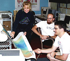
Uta Peckman finishes making a large multibeam bathymetry map, and studies it with Dan Scheirer (right) and Scott White in the Computer Lab. The map shows the changing water depths, and hence the seafloor’s elevation, in the area we have been surveying over the past few days. Uta, Dan, and Scott spend a lot of time each day making accurate maps that are used by the scientists and the person “flying” the DSL-120 or Argo II fish to tell if there is a hill or canyon ahead of the fish. When a hill is ahead, the fish has to be pulled up so that it doesn’t crash into it. If there is a canyon ahead, the fish is lowered to get a closer look at the bottom.
|
© 2010 Dive and Discover™. Dive and Discover™ is a registered trademark of
Woods
Hole Oceanographic Institution
