|
|
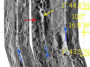
A mosaic of three DSL-120 sonar lines in the area where Dredge 10 was collected. The blue arrows are drawn along the nadir (or track line) of the sonar fish and show the direction that the lines were run. The yellow arrow points to the east side of the young volcanic mound where Dredge 10 collected the young volcanic lavas. You can see that the mound has covered the fissures and cracks of the ridge crest in this area. The red arrow points to the location of hydrothermal activity that we discovered today with Argo II! It is located on the west side of the volcanic mound along a line of fissures on the East Pacific Rise axis. Look at the next two slides for some preliminary photographs of the vent community!
|
© 2010 Dive and Discover™. Dive and Discover™ is a registered trademark of
Woods
Hole Oceanographic Institution
