|
Hot
Topics: Hotspots
& Cool Volcanoes: The New England Seamounts
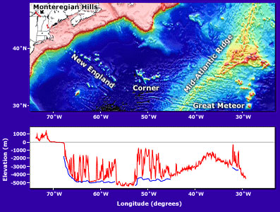
Map of the entire track of the hotspot that formed the New England
Seamounts and other associated volcanoes, from the Monteregian
Hills (red dots) in the west to Great Meteor Seamount in the east.
The bottom graph shows in red the height of the land and depth of
the seafloor along the hotspot track. Blue lines show the seafloor
depths surrounding the seamounts to emphasize the volcano heights.
|
