


« Previous | Next »
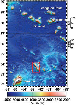
Another satellite-generated map showing the New
England Seamounts, with our home base Bermuda at bottom left and Muir
Seamount boxed in red. The numbers on the x-axis denote degrees of West
longitude lines, which scientists often denote as negative numbers; the
numbers on the y-axis denote degrees of North latitude. Maps with a relatively
large scale such as this one are useful for taking in the big picture,
literally. They help us figure out how best to plan how to organize,
and in what order to conduct, Alvin dives and other research endeavors.
« Back
to today's update | 