|
|
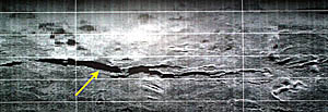
This DSL-120 sonar record shows just one side of the swath of sonar data, so the nadir is off the bottom of the image, and the record is only 500 meters wide (the horizontal white lines are 100 meters apart). The yellow arrow points to a large crack in the volcanic seafloor that is more than 1 kilometer long and as wide as 30-40 meters in places. You can see how it tapers (narrows) at each end and that it forms narrow finger-like cracks along its length. Cracks such as these are formed when seafloor spreading cracks the seafloor, like cracks that develop in the surface of taffy when you pull it. The bumpy or hummocky areas near the top of the sonar image are probably small volcanic cones.
|
© 2010 Dive and Discover™. Dive and Discover™ is a registered trademark of
Woods
Hole Oceanographic Institution
