|
|
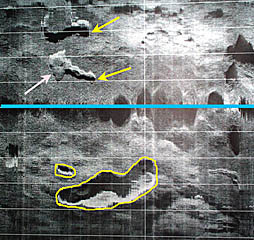
A DSL-120 sonar record from the 1° 40’-50’N area of the East Pacific Rise crest collected today. The yellow arrows point to fissures or cracks in the volcanic seafloor that are likely places for lava to erupt. The pink arrow points to a small lava flow that appears to have covered up part of the fissure and may have erupted from it. Yellow lines are drawn around two “collapse features”. The larger one may be a “lava lake” - a place where lava erupted and formed a small lake, but later it drained back into the underlying crust, leaving a large pit in the seafloor. All these places are likely to have young lava flows. The blue line in the middle of the record is the nadir -- the track of the DSL-120 “sonar” fish. The horizontal white lines are spaced 100 meters apart.
|
© 2010 Dive and Discover™. Dive and Discover™ is a registered trademark of
Woods
Hole Oceanographic Institution
