|
|
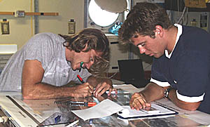
Greg Kurras (left) and Ben Wigham (right) compile observations from the first Argo II lowering that traversed about 35 kilometers of the axis of the Galapagos Rift valley. They are working on a light table and plotting the Argo II observations on top of the DSL-120 sonar maps. This way, they can relate the sonar imagery to the geology of the seafloor.
|
© 2010 Dive and Discover™. Dive and Discover™ is a registered trademark of
Woods
Hole Oceanographic Institution
