|
|
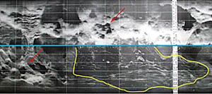
This DSL-120 sonar record collected last night shows an area on the seafloor that we suspect might have new volcanic flows. We saw lots of bumpy topography that is probably made up of small volcanoes a few tens of meters high and about a football field in area. Some of them are in groups, as in sonar image (see red arrows). The striking thing about this photo is the blackish area that is cut by many fissures (outlined by yellow). The blackish area is not dark. It is an area where sound from the sonar has not been reflected back strongly. We suspect that this may be a new lava flow and we are going to tow the sonar fish over the area again tonight to get a better look at it. The blue line is the nadir, or centerline, where the sonar fish was flying about 100 meters above the seafloor. This image is produced in real time, as we are towing the sonar over the seafloor. But we will be working hard in the next day to “process” the data to remove errors and distortions. We want to make the best possible image to help guide where we will sample lava and where we will tow Argo II to photograph the seafloor.
|
© 2010 Dive and Discover™. Dive and Discover™ is a registered trademark of
Woods
Hole Oceanographic Institution
