|


TODAY'S WEATHER Broken Clouds 79°F (26.1°C) Latitude: 9 deg 36’N Longitude: 104 deg 16’W Wind Direction: NE Wind Speed: 15 Knots Sea State: 3 Swell(s) Height: 1 Foot Sea Temperature: 82°F (27.8°C) Barometric Pressure: 1013.1 MB Visibility: 20 Nautical Miles  Breakfast Blueberry pancakes Ham & bacon McMuffin sandwiches Oatmeal Red potatoes Fresh fruit Lunch Salad bar Coleslaw Kosher hot dogs with homemade rolls Fried codfish Chicken & rice soup Beans and pasta (Pasta fagioloi) Chilikraut and grilled onions Dinner Teriyaki strip steak Marinated grilled salmon Stir fry rice Hawaiian style roasted potato Fresh string beans with almond butter Salad bar Hot fudge sundaes 
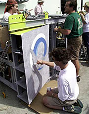
Paul Oberlander paints a porpoise on the Towed Camera Sled as it is being prepared for night time surveying. January 29, 2000 By Dr. Dan Fornari and Sam Dean After travelling full speed for nearly 2 days,
RV Atlantis finally reached its destination this morning
at 0710 hours. Under clear skies and fairly calm seas, the Alvin crew
started work early to deploy the transponders we will be using
during the dives at the East Pacific Rise. Above water, the ship
uses its military grade Global Positioning System (P-Code GPS)
to keep track of its position. It is accurate to less than 10
meters! So we know where we are on Earth with very great precision.
This is very important for accurately mapping the seafloor and
collecting many different types of oceanographic data. The transponders were all pushed over the side and sent to do their job at the bottom of the ocean by about 1000 hours. After they got to the seafloor, (it took them about an hour to descend) Pat Hickey spent most of the morning and early afternoon surveying them in. He did this using the P-Code GPS system and driving a circle around each one to collect acoustic travel-time information that tells us how far the transponder is from the ship at many points. This is called the acoustic slant range to the transponder. By driving a circle around each transponder, and knowing the ship’s position very accurately with the P-Code GPS, we can determine with great precision the location of each transponder. Each transponder is tethered 185 meters above an anchor weight. It is up this high so that the signals it sends and receives from Alvin are not obstructed by any hills. The briefings continued today as the Alvin pilots talked with the scientists about how to maneuver inside the sub, operate the video cameras, and what to do in case of emergencies, like having to pee! Everyone wants to know about what happens when you have to go to the bathroom in Alvin. Well, most people are careful of what they eat before hand and don't eat a heavy meal the day before their dive. They also make sure to go to the bathroom in the morning before they get in the sub. But some people still need to pee after a few hours in the sub and the Alvin group has special red bottles that men and women can use if they have to go. It’s pretty simple, and when you have to go... you HAVE to go, even if you are on the ocean floor! Up in the library, Dr. Margo Edwards talked about her research and experiences when she led an expedition using a US Navy nuclear submarine to map part of the Arctic Ocean basin last year. The room was packed with interested members of the science party, ship's crew and the Alvin group. We plan to have several lectures on different oceanographic and research topics during the cruise. Meanwhile, the Towed Camera Sled continued to take
shape and various pieces of equipment started to get mounted
on it. Greg, Jenny and Del worked all day to make sure that the
Sled is ready for its first run tonight. It’s amazing to
see a simple, large steel cage transformed over two days into
such a complex piece of surveying equipment! The Sled will be
lowered to 7-10 meters above the sea floor, while it is being
towed behind RV Atlantis at about 1/2 knots of speed
as it makes traverses over the East Pacific Rise axis. The sled
was put over the side at 2040 hours after a successful deck test
where it flashed 5 times, indicating it was ready to get dunked
and go to work taking pictures of the lava flows on the seafloor.
|
||||||||||||||||||||||||||||||||||||||||||||||||||||||||||
© 2010 Dive and Discover™. Dive and Discover™ is a registered trademark of
Woods
Hole Oceanographic Institution
