|
|
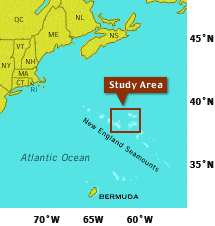 Click HERE for a bathymetric map of the study area. Collecting Deep-Sea Corals Dive and Discover’s 2003 expedition will journey to the New England Seamounts The scientific treasures the expedition seeks are deep-sea corals Scientists think that abrupt climate changes may have been caused by changes in the circulation of the deep ocean. In particular, they think that a cold, salty, deep water mass The New England Seamounts rise thousands of meters up from the seafloor, right into the pathway of this deep, cold water mass. On the seamounts grow large populations of deep-sea corals. Throughout their lives, coral skeletons absorb chemicals from the waters they are growing in. By analyzing the coral skeletons, scientists can determine how old the corals are and whether the cold, deep water was flowing when they lived. By sampling live and fossil corals from the top to the bottom of the seamounts, they hope to find out how and when this deep water mass grew larger or smaller, became warmer or colder, and flowed higher or lower in the depths-as far back as 70,000 years ago. Expedition 7 travels to the New England Seamounts,
a chain of extinct, undersea volcanoes about 500 miles off the
east coast of North America. On the seamounts themselves grow one
of the chief targets of the cruise: deep-sea corals. These are
similar to corals found in shallow, tropical waters but they don’t
have symbiotic The corals’ skeletons are rich repositories of environmental information. The biochemical composition of their skeletons is different if they grow in different water conditions. And water conditions change as Earth’s climate does. Like undersea tape recorders, individual corals at different depths in the ocean have recorded how Earth’s climate has changed through time. But getting those corals back to the lab is not the only goal of the expedition. Our broader aim is to use the New England Seamounts as a test case: What we learn about retrieving and studying corals here will show us the best ways of getting other corals in the future, from the deep Pacific Ocean to the waters off Antarctica. The first day the vessel Atlantis arrives at a particular seamount, it will go back and forth over an area with sonar Both Alvin and the unmanned vehicle ABE, the Autonomous Benthic Explorer, will collect overlapping photos of the seafloor that we will combine to make photomosaics. We will also generate additional maps that are focused on smaller areas but with much more detail. By putting these maps together with the large-scale maps made by Atlantis, we will come up with some general guidelines that scientists can use to find information-rich corals anywhere. In the future, we hope that scientists will look at topographic maps of the sea floor and be able to determine the likeliest places to find corals. Alvin will be doing the heavy lifting -- of both living and fossil corals. The principal coral we expect to find is Desmophyllum cristagali, which grows roughly one millimeter per year for several decades, or sometimes up to 150 years. Other corals on the seamounts are Enallopsamia rostrata and Lophelia pertusa. Once aboard, the corals will be documented, photographed, cleaned (the dead ones) and tissue-sampled (the living ones) for genetic and reproductive analysis to yield a sort of detailed family tree. While all the physical evidence is being processed, digital data will be assembled: maps, photo and video documentation, and information about local environmental conditions such as temperature, salinity, and current speed. This database of coral habitats in different climates is another important goal of the cruise. The full scientific value of the corals will become apparent only partially during Expedition 7. Atlantis has laboratory facilities that will allow scientists to study the treasures they’ve retrieved, but many of the most perplexing problems will take months or more to solve, after the corals have been brought back to more sophisticated labs on shore. There, they’ll undergo more sophisticated uranium-series
|
||||||||||||||||||||||||||||||||||||||||||||||||||||||||||||||||||||||||||||||||||||||||||||||||||||
Mailing List | Feedback | Glossary | For Teachers | About Us | Contact
© 2010 Dive and Discover™. Dive and Discover™ is a registered trademark of
Woods
Hole Oceanographic Institution
