| January:
Daily Updates |
| S |
M |
T |
W |
T |
F |
S |
| |
|
|
|
|
|
1 |
| 2 |
3 |
4 |
5 |
6 |
7 |
8 |
| 9 |
10 |
11 |
12 |
13 |
14 |
15 |
| 16 |
17 |
18 |
19 |
20 |
21 |
22 |
| 23 |
24 |
25 |
26 |
27 |
28 |
29 |
| 30 |
31 |
|
|
|
|
|
| February: Daily Updates |
| |
|
1 |
2 |
3 |
4 |
5 |
| 6 |
7 |
8 |
9 |
10 |
11 |
12 |
| 13 |
14 |
15 |
16 |
17 |
18 |
19 |
| 20 |
21 |
22 |
23 |
24 |
25 |
26 |
| 27 |
28 |
|
|
|
|
|
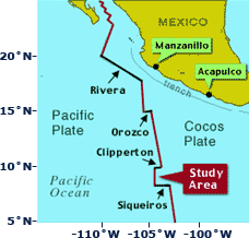
Location map showing the Pacific and
Cocos plates and the East Pacific Rise (bold red lines),
and the mid-ocean ridge plate boundary where the plates are
separating. The black lines that offset the ridge are transform
faults, places where the plates slide by each other. |
Mission
How Does the Mid-Ocean Ridge Work
- I
Join Dive & Discover for a 10 day Alvin diving cruise to the volcanoes
and hydrothermal vents on the deep sea floor in the eastern Pacific Ocean.
Dive & Discover’s 2nd voyage takes you
about 500 miles south of Manzanillo, Mexico to the crest of the
East Pacific Rise , a volcanic ridge where the crust of the Earth
is being constantly created. Seafloor spreading is separating the
Pacific Plate from the Cocos Plate at a rate of 11 centimeters
(about 5 inches) every year. Beneath the tropical waters of the
eastern Pacific, there is a mountain range made up of many active
volcanoes erupting lava that forms the top 500 meters (about 1,640
feet) of the Earth’s crust. The lava flows have strange and
wonderful shapes. Some look like they have been squeezed out of
a tube of toothpaste to form long cylinders with deep grooves in
them, others form big, cracked pillows of rock that look like overstuffed
sofas; there are even lava flows that look like ropey swirls of
black taffy. , a volcanic ridge where the crust of the Earth
is being constantly created. Seafloor spreading is separating the
Pacific Plate from the Cocos Plate at a rate of 11 centimeters
(about 5 inches) every year. Beneath the tropical waters of the
eastern Pacific, there is a mountain range made up of many active
volcanoes erupting lava that forms the top 500 meters (about 1,640
feet) of the Earth’s crust. The lava flows have strange and
wonderful shapes. Some look like they have been squeezed out of
a tube of toothpaste to form long cylinders with deep grooves in
them, others form big, cracked pillows of rock that look like overstuffed
sofas; there are even lava flows that look like ropey swirls of
black taffy.
How did these lavas form? When did they erupt? How
do they build up to form the ocean crust of the Earth? How are
hydrothermal vents, like the ones studied during Dive & Discover’s
first cruise to the Guaymas Basin, related to these undersea eruptions
and lava flows?
During Dive & Discover’s Cruise 2, scientists,
engineers and students from several universities will use Alvin,
armed with very sensitive instruments, to find out the answers
to these questions. At night, while Alvin’s batteries
are charging, they will also tow behind the ship a specialized
camera sled which has a digital camera to take pictures of the
volcanic seafloor. This will help them map the seafloor and understand
how and where lava erupts deep in the ocean and how it builds up
to form the ocean crust.
Research at this site on the East Pacific Rise got
a boost in 1989 when Dr. Dan Fornari from Woods Hole Oceanographic
Institution (WHOI) and Prof. Rachel Haymon of the University of
California-Santa Barbara went to the crest of the East Pacific
Rise between 9°N and 10°N Latitude to map the mid-ocean
ridge crest using a towed camera and sonar system called Argo [Click
here to learn more about Argo]. On that cruise they found many
hydrothermal vents and evidence for a large volcanic eruption that
covered several miles of the ridge crest with new, pillowy black
lava. They went back in 1991 to dive at the East Pacific Rise crest
to sample the hydrothermal vents and lava. What they found shocked
them! When they dove to the seafloor in Alvin, they realized
that there was a submarine volcanic eruption going on, and that
hot, new lava had covered the seafloor, covering some of the hydrothermal
vents they had seen just 2 years before with the Argo system, even
cooking some of the tubeworms!
Now a team of geologists and geophysicists led by
Dan Fornari and Jim Cochran of Lamont-Doherty Earth Observatory
are returning to the East Pacific Rise with Alvin to study
and sample the lava flows and hydrothermal vents. They will be
using sensitive instruments to measure very small changes in the
Earth’s gravity and magnetic fields to help them learn about
the ocean crust and the lava that forms it. Just like a doctor
using a stethoscope to find out what’s going on inside a
human body -- medical remote-sensing -- Dan, Jim and their colleagues
will be using geophysical remote-sensing to study the Earth’s
ocean crust.
Join them as they explore the volcanic seafloor of
the East Pacific Rise and try to understand what is underneath
it -- inside the ocean crust, and monitor the biological and chemical
changes at the hydrothermal vents since the 1991 eruption.
Objectives
What is Geophysics
Geophysics is the study of the Earth using the principles of physics. A geophysicist
is someone who uses instruments to tell them about the Earth, rather than “seeing” it
first-hand. These techniques, for example, using the speed of sound in different
layers of the earth, or the study of Earth’s gravity and magnetic fields,
help them to understand the internal structure of the planet. By using these
methods, geophysicists have been able to tell what the “anatomy” of
the Earth is. Geophysics is one of the most important methods for understanding
where earthquakes take place and how to help prevent or minimize damage caused
by them in cities like Los Angeles. Geophysics is also an important tool that
helps scientists and engineers find oil and gas.
Looking into the Earth - Geophysics is the
Key!
How do you see inside the Earth? On land, you can dig a trench to see the layers
of sediment, look at the side of a cliff to see the layers of rocks and how
they are folded, or go down into a mine to see the rocks inside the crust.
At the mid-ocean ridge, looking inside the Earth is much more difficult. First
of all, there are 2500 meters (8200 feet) of sea water between you and the
rocks exposed on the seafloor. Alvin allows scientists to go down
to the seafloor, make observations and sample the rocks, but getting information
on what is below the seafloor is more difficult - you need different instruments
and techniques to do that. That’s where geophysics comes in!
Objectives
Scientists on this cruise will use two different geophysical measurements to
find out about the upper part of the ocean crust at the East Pacific Rise
near 9° 37’N Latitude. The scientists are going to use two types
of electronic instruments- one to measure small variations in the Earth’s
gravity field and the other to measure small variations in the magnetic field
along the axis of the East Pacific Rise. They will also be taking thousands
of digital pictures of the seafloor using Alvin and a towed camera
sled so that they can make detailed maps of the volcanic terrain and relate
them to the gravity and magnetics. Together, this information, or data, will
help them answer questions like these:
- How do seafloor lava flows build up over time to
form the ocean crust?
- Does the lava always erupt in the same place at the
ridge axis?
- When it does erupt, how far does it travel from the
fissure or crack where it started?
- What happens to deep ocean hydrothermal vents when
there is a volcanic eruption?
Hypothesis to Test
1. The pattern of dikes, or feeders that supply lava to the seafloor from the
magma chamber underneath the East Pacific Rise axis can be mapped using gravity
and magnetic data collected near the seafloor with Alvin.
[Back to top]
|
