|
|
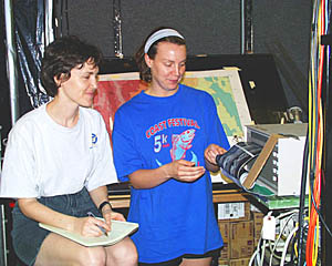
Watch leader Maya Tolstoy and Julia Getsiv look at the first four hours of the DSL-120 sidescan sonar records as they are coming off the plotter. Directly behind Julia is the multibeam bathymetry map on which Julia plots the positions of the ship and the DSL-120 sonar “fish” every ten minutes. P.J. Bernard, who is “flying” the vehicle over the seafloor then knows whether hills or valleys will be coming up.
|
© 2010 Dive and Discover™. Dive and Discover™ is a registered trademark of
Woods
Hole Oceanographic Institution
