|
|
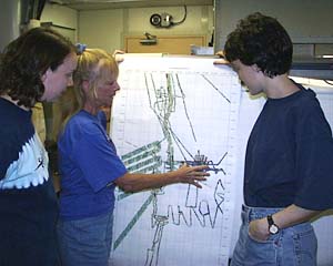
Uta Peckman (center), the Scripps multibeam data processor, explains the bathymetric map she has just made to Julia Getsiv (left) and Maya Tolstoy in the Main Lab. The colored lines on the map show swaths of contoured bathymetric data (seafloor topography) for the area we are going to be working in over the next few weeks. The multibeam sonar system on board RV Melville can produce swaths of contoured bathymetry that are about 3.4 times the water depth in width. The East Pacific Rise is 2500m in depth -- so how wide a swath of data can the multibeam system collect? The answer is 8.5 kilometers.
|
© 2010 Dive and Discover™. Dive and Discover™ is a registered trademark of
Woods
Hole Oceanographic Institution
