|
|
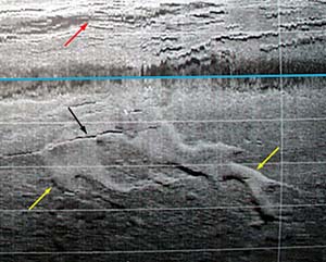
A sinuous (curvy) lava flow is very well displayed
in this DSL-120 sonar record. The two yellow arrows point to the
edges of it. Can you follow where the flow went? The black line
points to the fissure, or crack, where we think the lava probably
erupted. The red arrow at the top points to the cracks and fissures
of the axial summit trough. The blue line is the nadir, or centerline,
of the record and marks the line along which the sonar fish was
towed.
|
© 2010 Dive and Discover™. Dive and Discover™ is a registered trademark of
Woods
Hole Oceanographic Institution
