|
|
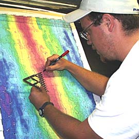
Erin Todd, a student from the University of Florida, plots the position of the DSL-120 sonar “fish” on the bathymetric map of the East Pacific Rise in the Control Van. We keep track of the sonar all the time to make sure we are surveying where we had planned, and to make sure we do not run the sonar “fish” into any volcanic cones sticking up from the seafloor. The crest of the Rise is shown by the red color on the map. Erin is using an instrument called a “ten point divider”. It can be expanded and contracted to fit any space, and then the “points” divide that space into ten equal parts.
|
© 2010 Dive and Discover™. Dive and Discover™ is a registered trademark of
Woods
Hole Oceanographic Institution
