Oceanographic Tools: Satellite Navigation
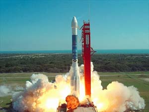
A GPS satellite being launched on a Delta II Booster rocket.
More than 60 GPS satellites have been launched over the past 30 years. Photo
by U.S. Coast Guard Navigation Center.
Ships use satellite navigation to find
their positions in the middle of the ocean. Each satellite is in a constant,
or fixed, orbit around the Earth and its position is determined very precisely
by the military using several ground stations and antennas around the world.
The primary ground station is located in Colorado Springs, Colorado.
The Global Positioning System (GPS) is a satellite-based radio navigation system
that permits people on land, at sea, and or in airplanes to determine their three-dimensional
position and velocity. The GPS also provides users with very accurate time. All
of this information is available 24 hours a day in all weather, anywhere on Earth.
Since the system was first put into use over 30 years ago, many satellites have
been launched.
The GPS was developed by the US Department of Defense primarily for military
applications during the Cold War, but for about the last 25 years oceanographers
have also been able to use satellite-based navigation to determine their position.
Knowing precisely where you are is important because all of the data and observations
you are collecting have to be referenced to a position on the Earth’s surface,
or in our case, on the seafloor. In addition, we often want to return to a scientifically
interesting seafloor site, which would be almost impossible to relocate without
satellite navigation.
Normally four or more satellites are used to “fix” a ship’s
position. The satellites and the receivers on the ship all have very precise,
synchronized clocks. Satellites send radio waves to the ship and the clocks measure
how long it takes for the signals to travel from the satellites to the ship.
 |
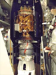 |
| A GPS satellite loaded into the nosecose of the
delivery rocket. The folded-up gold foil is designed to spread out into
the solar panels which provide power to run the satellite when it is
orbiting in space. Photo by U.S. Coast Guard Navigation Center. |
The longer it takes, the longer the distance between satellite
and ship. In this way, time is converted to distance. Using measurements from
at least three satellites (a method called triangulation), computers can calculate
the unique point on the face of the Earth where all three (or more) distances
measured from all the satellites intersect. That is where the ship is!
The current group, or constellation of GPS satellites now numbers 24. They are
located in six circular orbits 20,200 kilometers (10,900 nautical miles) above
the Earth at an inclination angle of 55 degrees. The satellites are spaced in
orbit so that at any time a minimum of 6 satellites will be in view to users
anywhere in the world. The satellites continuously broadcast their position and
time data to users throughout the world. The civil GPS system, similar to that
used on pleasure boats, and now in cars, has an accuracy of less than 100 meters.
The system that most US oceanographic ships use is called P-code GPS -a military-grade
system with an accuracy to 10 meters. This is the same system that the US armed
forces uses for its ships, planes and surface transport systems.
Back
|
