Oceanographic Tools: DSL120
 DSL 120 DSL 120
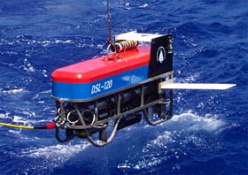
The DSL-120A is a towed sonar vehicle
measuring 11-feet (3.3 meters) long. Scientists use the sonar to
map underwater terrain using sound energy. The DSL-120A is equipped
with two side-scan sonars—one that maps to the right, and one that
maps to the left.
The DSL-120A is an
underwater vehicle that is tethered to the ship by a long fiber
optic cable. Scientists use the DSL to map underwater terrain.
However, instead of using light to map the bottom, it uses sound.
For more information visit WHOI's Marine Operations
DSL
120 Page
The DSL-120A is equipped
with two side-scan sonars—one that maps
to the right, and one that maps to the left. Each sonar has one pinger that
sends sound waves to the ocean floor once every 0.8 seconds,
and two receivers that catch the echoes.
The sonars gather two types of information. First,
they measure the intensity of the returning signal. Just as a tennis
ball bounces higher off of a driveway than off of the soft grass,
the sound waves bounce harder off of hard surfaces than soft surfaces.
Second, the sonar measures the bathymetry or contours of the surface it is mapping.
Here is where the two receivers come into play. When the pinger bounces a signal
off of a flat area, the echo should reach the two receivers at the exact same
time. If, however, the pinger bounces the signal off of a slope, the echo returns
at a different angle and reaches one of the receivers before the other. The time
interval between when the echo reaches the first receiver and the second receiver
is called the phase shift. The length of the phase shift depends on the slope.
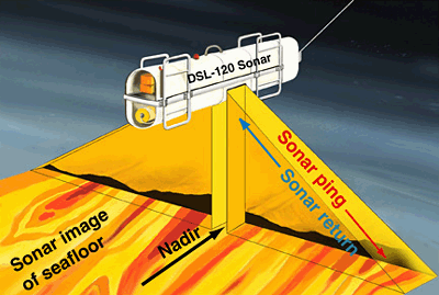
This is a cartoon of how the DSL-120 sonar works.
The sonar sends out pings to both sides every 0.8 second at a frequency
of 120 kHz, which is a pretty high pitched noise. The sound energy
travels down to the seafloor at about 1500 meters per second. It
bounces back from the seafloor and is received at the “sonar fish” a
short time later. The signal is then sent up the fiber optic cable
to the Control Van.
The sonar computers use the time delay and the strength of the
returned signal to (1) make an image of the bottom like the one
in the next slide, and (2) make a map of the depth of the seafloor.
At the 2500 meter depth of the East Pacific Rise crest, the DSL-120
sonar can “see” and image features on the
seafloor that are as small as a few meters on either side, or about the size
of your dinner table!
|
