
 |
|
|
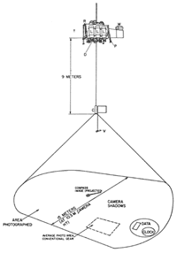
Project FAMOUS used the U.S. Navy’s LIBEC camera system, which suspended high-intensity electronic flash lamps well above the ocean bottom. (Courtesy of U.S. Naval Research Laboratory) |
|
 |
|
|
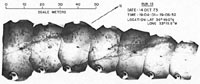
The LIBEC system shot 120-foot-wide sections of the seafloor that were pieced together. (Courtesy of U.S. Naval Research Laboratory) |
|
 |
|
|
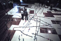
LIBEC collected 5,250 seafloor photos, which were fitted together and laid across the floor of a Navy gymnasium in Washington, D.C. (Photo by Emory Kristof © National Geographic Society) |
New tools for an historic mission
For this historic expedition, the U.S. Navy mapped the FAMOUS target area with its powerful and top-secret Sonar Array Survey System (SASS)—the first time oceanographers gained access to such detailed seafloor data.
The U.S. Naval Research Laboratory also sent out the U.S.N.S. Mizar with LIBEC (LIght BEhind Camera), a deep-sea photography system built after the submarine Thresher’s tragic sinking. LIBEC suspended high-intensity electronic flash lamps well above the ocean bottom, making it possible to shoot 120-foot-wide sections of the seafloor.
Woods Hole built a deep-towed camera sled called ANGUS (Acoustic Navigated Geological Undersea Surveyor) specifically for Project FAMOUS.
LIBEC collected 5,250 seafloor photos, which were fitted together and laid across the floor of a Navy gymnasium in Washington, D.C. Scientists wandered over the giant jigsaw puzzle of photos to get their first glimpse of conditions they would encounter on the seafloor.
In the summer of 1973, Archimède made seven reconnaissance dives to the ridge, bringing back rock samples and close-up photographs. Project FAMOUS was ready to go.
| Page 5 |