
 |
|
|
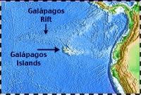
Seafloor topography in the eastern Pacific Ocean. (Map by Paul Johnson, U. of Hawaii-HMRG, using satellite altimetry data) |
|
 |
|
|
Scientists prepare to lower a heat-flow probe to the seafloor from the fantail of R/V Thomas Washington in 1972. The probe allows scientists to calculate heat flowing through seafloor sediments. (Photo courtesy of Scripps Institution of Oceanography) |
Where’s the best place to search for vents?
With many early clues piling up to suggest that hydrothermal vents existed, scientists grew more eager to find one. Seagoing expeditions are difficult and expensive, so scientists had to zero in on a place where they thought they would have the best chances of finding vents. Of all the mid-ocean ridges in the world, which was the best place to look for vents?
Aside from actually going down to the seafloor to witness vents with their own eyes, the best way for scientists to find vents was to lower instruments to the ocean bottom to detect hot water or measure heat flowing in seafloor sediments. They needed an active volcanic ridge where they could insert their temperature probes into the seafloor. The probes wouldn’t go into hard lava, so they looked for a location near a ridge crest where the seafloor was covered by a thick blanket of softer sediments.
The Galápagos Rift seafloor had the right characteristics. Scientists at the Scripps Institution of Oceanography in La Jolla, California knew the area relatively well. Three Scripps research cruises in 1966, 1969 and 1970 collected heat-flow measurements at the Galápagos Rift, as well as temperatures of ocean-bottom waters. The measurements —analyzed by Scripps scientists John Sclater and Kim Klitgord—showed some evidence that hydrothermal venting was occurring at the Galápagos Rift.
| Page
2 |