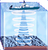
To map the seafloor, scientists bounce a beam of sound waves off the ocean bottom. Research ships moving along the sea surface repeatedly “ping” the seafloor with sound to map a continuous line of seafloor elevations below.
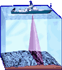
By sending out many beams of sound simultaneously, research vessels can collect data on a wide swath of the seafloor, rather than a single line. So they can map much larger areas during a single cruise.