
To determine their precise location in the middle of the ocean, ships keep in touch via radio waves with a network of globe-orbiting satellites-the Global Positioning System (GPS).
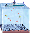
Radio waves used by satellites don't penetrate far below the ocean surface. So scientists use sound waves to vigilantly track the locations of deep submergence vessels traveling in the dark ocean depths.