|
Multibeam
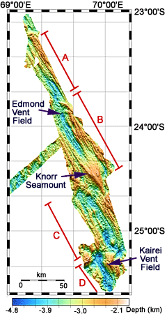
bathymetric map made from sonar data collected during this cruise.
DSOG tech Paul Johnson processed the data which show the different
segments (labeled A-D) of the Central Indian Ridge rift valley between
23°S and 25.5° S. Knorr seamount sits in rift valley at the south
end of segment B. The locations of the Edmond and Kairei Vent Fields
are also shown.
|