 |
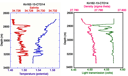
| CTD data plots during our Tow-Yos in the 24°S area of the Central Indian Rift valley. The left plot shows the distribution of temperature (°C) and salinity (parts per thousand). The right plot shows density and particles (light transmission). The vertical axis is water depth. Some of the “spikes” or jagged parts of the colored lines indicate warmer water. The warm water is buoyant - it is still rising up from a seafloor vent carrying loads of particles. We followed the signals shown on these plots for miles until we finally found a stronger signal. This told us that the seafloor vents were below us. |